
The “South Shore” Wooden Trestle Story Revisited
By Monica Wooton

Fig. 1. The trestle system at Smith Cove,
used for commercial shipping by train and boat.
By Elizabeth A. Cooper, untitled, watercolor and gouache on paper, 1919. Cascadia Art Museum, Edmonds, WA.
In writing history, it is always interesting to see better sources, new research, and time shed light on a previously accepted historical fact, revealing a different story. This is one of those stories.
In 2015, I began revisiting the history of the “South Shore Trestle,” which had been featured in Hal Will’s chapter for Magnolia: Memories & Milestones, published in 2000 (1). Will carefully researched, laid out, and labeled the wooden trestles of Magnolia, which date to the 1900s, using the facts available to him at the time. The South Shore Trestle, assumed by Will to be a separate trestle built after the West Garfield Trestle, wrapped around the south shore of Magnolia Bluff and was built out on tideland “streets” (West Lee Street and Logan Avenue). It appeared to join land again at 32nd Avenue West (2). Will dubbed it the “South Shore Trestle” in the absence of an official recorded name.
Additional research done in 2015 and more recently—benefiting from the digitization of and increased access to records from the Seattle Municipal Archives, Seattle Post-Intelligencer, and The Seattle Daily Times—has contributed new and interesting perspectives on the history of the so-called “South Shore Trestle” we knew so little about in 2000.
In 2015, the Magnolia Community Club (now Council) wanted to see if this trestle set any historic precedent for the Magnolia-to-Elliott Bay Marina bike path connection they were proposing.
Bike path precedent from the 1900s
The Magnolia Community Club had a theory that the “South Shore Trestle” could have been used by bicyclists in an earlier era near the geographical area they were looking to put the new bike path. If so, it could possibly set a historical precedent for their project. Surprisingly, I learned there were many Seattleite bicyclists of that early 1900s era—ten thousand at the turn of the century. One in eight Seattle residents owned a bike (3). And the twenty-five mile bike path of 1900, which was designed by George F. Cotterill, went past the proposed bike path’s general area, albeit not on the south shore, but above it, where Magnolia Boulevard would one day be built. So, perhaps some informal bike paths had been established to set a precedent. But after much research, the answer to that theory became a complicated “No.” (See sidebar on bicycle path at the end of this story. )
The “South Shore Trestle” history revisited
Will’s theories of the construction dates and configurations of the major trestles were slightly inaccurate. His interpretation of the 1912 Baist real estate map for evidence of the trestles was not the same as mine. On the 1912 Baist that I consulted, the only two trestles shown are at West Dravus Street and West Garfield Street, running out on tidelands around the South Bluff of Magnolia to 32nd Avenue West. (The map incorrectly showed that the West Garfield Trestle ran on 22nd Avenue West, but it actually ran on 23rd, per City of Seattle Ordinance 25390.)
Will did not see that the West Garfield Street Trestle included the “South Shore” portion. Additionally, the 23rd Avenue West Trestle to West Newton was not shown on the 1912 Baist. The West Garfield Trestle remained unconnected to Magnolia until around the time the 23rd Avenue West to West Newton Street Trestle was declared finished seven months later (4).
Will had claimed the 23rd Avenue West Trestle was shown on the map. It was not. He was correct when he stated: “These two structures [West Garfield Street and 23rd Avenue West trestles] provided the first vehicular access to the Bluff across the tide flats south of West Dravus Street” (5). This was the first and only south-ish connection to Magnolia Bluff, and would remain that way for two decades, until the West Garfield Street Bridge (the Magnolia Bridge) finally provided a connection to the southern part of Magnolia Bluff.
Will also assumed that the 23rd Avenue West Trestle, which veered north from the West Garfield Street Trestle to Newton Street, was built before the “South Shore Trestle.” But it was, in fact, built after—changing the order of which trestles were built when on Magnolia.
I am unsure why we had different map readings. But it meant this trestle history could be shifting. And this made me wonder.
At the time Will was studying trestles of Magnolia, he believed the “South Shore Trestle” was a separate trestle on its own that was eventually joined to the West Garfield Street Trestle. Details were lacking. Photos never fully revealed the west upland connection. It was assumed that a trestle of this enormous length would be connected to the adjacent uplands. The photos and topography pointed to 32nd Avenue West as the logical upland connection, which was also where Wolf Creek flowed through fairly flat land to Puget Sound. However, I discovered the South Shore Trestle was not a separate trestle on its own. And it was not connected to land at 32nd Avenue West as assumed.
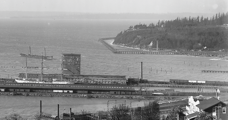
Fig. 2. This photo shows the development at Smith Cove. The piers and square silo were part of the granary there at the time.
Caption from “Magnolia’s Wooden Trestles,” Magnolia: Memories & Milestones, p. 202: “This photo of the south end of Magnolia Bluff from Queen Anne Hill clearly shows the ‛South Shore Trestle’ that permitted traffic from the Garfield Street (wooden) trestle to the Wolfe Creek ravine (32nd Avenue West). It is estimated that this view was taken about 1911. No views have been found of the Wolfe Creek end. # 83.10.9385.
Courtesy of the Museum of History and Industry, 1911.”
New research revealed the so-called South Shore Trestle was built, in fact, as part of the West Garfield Street Trestle. The entire structure was completed on June 16, 1911 (6). According to Darin Deehr, Department of Natural Resources Property Acquisition Specialist: “The first class tidelands in front of Magnolia Bluff were sold to [t]he Seattle and International Railway Company in 1899 and to D. A. Robinson and J. D. Farrell [for $951.33] in 1902. The Harbor Area fronting these tidelands was leased to these individuals for a 30-year period 1900–1930” (7, 8). Further research revealed that D. A. Robinson was employed by J. J. Hill to oversee much of the Great Northern Railway buildings and structures (9). J. D. Farrell was a well-known business leader of the era; eventually, after several mergers of local and national energy companies, he became president of the Seattle Light Company and subsequently president of the Great Northern Steamship Company (10, 11). A statement of cost for the trestle was sent to Alex Stewart, Assistant Chief Engineer at the Great Northern Railway Company in Seattle, for $13,113.74 (12). The original lease with the Seattle International Railway, later part of the Great Northern Railway, states it was granted for “the purpose of building and maintaining wharves, docks and other structures upon the said described harbor area for the convenience of navigation and commerce” (13).
One long road to nowhere
It is now known that several railway companies, certain business individuals, and the Chamber of Commerce were involved with plans to build up Magnolia as an industrial center (14). The West Garfield Street Trestle—at twenty-six feet wide and a little over two thousand feet long, just shy of a half a mile—was supposed to be a part of the equation, especially the “South Shore” portion (15). The West Garfield Street Trestle seemingly provided a connection to the vicinity of the South Bluff of Magnolia, but no direct connection actually came until the steel and concrete Garfield Street Bridge, a Warren deck truss bridge, (now the Magnolia Bridge) was constructed in December 1930 (16).
Additional research of this unusual and now very, very long West Garfield Street Trestle proved that the so-called “South Shore” portion was never really connected to the shore and used as intended. It was virtually “a road to nowhere” from 1911 until April 14, 1920, when it rotted and fell into the sound over a three-day period (17). Then-superintendent of streets Charles R. Case commented: “There is little likelihood of the bridge being rebuilt…it was built originally at the behest of certain real estate interests and the Chamber of Commerce which hoped for certain industrial developments in that part of the city that failed to materialize” (18).


Fig. 3. Old trestle order and sections in Will’s drawing as it appeared in Magnolia: Memories & Milestones, 2000, p. 198.
Courtesy of Monica Wooton. 2025.
Fig. 4. Corrected version. Hall Will listed eight possible trestles. We now know there were five, and they were built in a
slightly different order.
Courtesy of Monica Wooton. 2025.
When Monica Wooton’s great friend Hal Will, historian and writer extraordinaire, decided to do a chapter on the wooden trestles of Magnolia in Magnolia: Memories & Milestones, Monica knew very little about them and was intrigued. The chapter was designed to precede Joy Carpine’s chapter on the building of the West Garfield Street Bridge (now Magnolia Bridge) in the same publication. Historically, trestles were the precursors to modern bridges, and Magnolia had an unusual amount of them for a peninsula. Monica followed the development of the story closely with interest. They were stumped by the “South Shore Trestle,” as Will called it, and often discussed theories. When the opportunity came to do more research on it for MCC many years later, Hal had passed. But Monica knew that any new information would be a great find and might solve the mystery of that trestle. Being a great historian and researcher, Hal would have loved what she was able to uncover with new information available!
Notes
-
Hal Will, “Magnolia’s Wooden Trestles,” Magnolia: Memories & Milestones, Magnolia Community Club, 2000, pp. 196–203.
-
“Magnolia’s Wooden Trestles,” p. 203.
-
Knute Berger. “How Bikes led Seattle’s first roads renaissance,” Cascade PBS, 23 Sept. 2013, https://www.cascadepbs.org/2013/09/seattles-first-golden-age-bikes.
-
A. H. Dimock, letter to William J. Bothwell, 23 Feb. 1912, Seattle Municipal Archives.
-
“Magnolia’s Wooden Trestles,” p. 199.
-
R. H. Thompson, letter, 19 Jul. 1911.Author’s note: Local improvement district (LID) No. 2265 was formed by City of Seattle Ordinance Number 25390 on October 17, 1910; filed with City Clerk on October 20, 1910, and signed by the Mayor the same day.
-
Darin Deehr, email to Monica Wooton, 23 Jan. 2015.
-
State of Washington Lease, 19 May 1902.
-
“The Great Work Moving: Mr. Robinson to Construct Great Northern Buildings,” The Seattle Daily Times, 20 Sept. 1898, p. 4.
-
“C.R. Collins May Retire: J.D. Farrell to Be President of New Seattle Lighting Company,” The Seattle Daily Times, 18 Mar. 1904, p. 4.
-
“Governor, State Officials Visit Objects of Interest in Seattle,” Seattle Post-Intelligencer, 15 Jan. 1905, p. 1.
-
R. H. Thompson, statement, 2 Jun. 1911, Seattle Municipal Archives.
-
S. A. Callvert and C. S. Mellon, legal document, 1 Feb. 1900, State of Washington.
-
Monica Wooton. “Unbuilt Magnolia,” Magnolia: More Memories & Milestones, Magnolia Historical Society, 2025, https://www.magnoliahistoricalsociety.org/book-iv.
-
Ordinance 32879, passed March 23, 1914, signed April 3, 1914, City of Seattle.
-
Joy Carpine, “Critical Connection: Bridge to the Bluff,” Magnolia: Memories & Milestones, Magnolia Community Club, 2000, pp. 204–215.
-
“Fifteen Homes Menaced When Trestle Drops.” The Seattle Daily Times, 14 Apr. 1920, p. 1.18.“Wreck Recovered.” The Seattle Daily Times, 11 Apr. 1920, p. 4.
-
“Wreck Recovered.” The Seattle Daily Times, 11 Apr. 1920, p. 4.
Seattleites Like Biking to Magnolia: Bicycle Path of 1900
George F. Cotterill, mayor of the city of Seattle in 1912, was a founding member of the Queen City Good Roads Club, what we might now call a bicycle advocacy group. Cotterill was involved in surveying and designing a twenty-five mile bike path system in the late 1800s and early 1900s that laid the groundwork for the city’s future boulevard system, including Magnolia Boulevard.

Fig. 1. Guide map to Seattle bicycle paths north of Yesler Avenue, 1900.
Image source: Jean Sherrard, “Seattle Now & Then: Biker's Choice,“ Seattle Now and Then, June 25, 2011.
The Seattle Times’ “Sporting News and Gossip” column printed on April 6, 1900 read: “The new Magnolia Bluff path can now be used by cyclists. It has been cindered and rolled, and has been pronounced by George F. Cotterill of the Queen City Roads Club to be in splendid condition.”
One week later, “Sporting and Athletic News” in The Times reported further:
“…to ascertain [the path’s] beauty and its many advantages one must travel over it from beginning to end, and even then half of the beauties of the road will be missed…the view of the city, harbor, and of Mount Rainier is most comprehensive [above Smith Cove]…The terminal shipping of the Great Northern Railway seems but a stone’s throw below the rider…Pleasant Valley provides the thirsty with pure spring water [now 32nd, 33rd and 34th Avenues West, water most probably from Wolf Creek], 2 miles through a forest where in addition to the firs, there is a close interlocking of maples so thick in many places the path presents the appearance of a tunnel cut through rich foliage…From the Lookout Point the most interesting view is that of the West Point Lighthouse and grounds…then…to [just established] Fort Lawton.”
The route from the city center at Yesler Way was ten miles, and it was known for its rigor as well as its beauty.

Fig. 2. Magnolia Boulevard bicycle path circa 1898.
Photo by Anders Beer Wilse. Courtesy of MOHAI, #88.33.239.
The same column reported that City of Seattle Ordinance 4460 required riders obtain a bicycle license for one dollar, with a fine of five or ten dollars if caught riding without one. And Ordinance 4210 required having a bell “rung before approaching person or conveyance” and a light making the sidewalk visible for two hundred feet if riding after the streetlamps were lit. The same ordinance mandated keeping to speed limits “of eight miles per hour on sidewalks and ten miles on streets, and when passing a pedestrian on sidewalk reduced to four miles per hour,” as well as biking, for wheelmen and lady cyclists, “single file on sidewalks and not more than 2 abreast…” Some sidewalks were not to be used for bicycles, mainly in downtown Seattle. “Coasting” was prohibited.