The following provides a general time line for events affecting Magnolia Boulevard:
Prior to 1857: Conifers logged from Magnolia Boulevard.
1857: Navy botanist and geographer Lt. George Davidson, not recognizing madrona trees, names Magnolia Bluff.
1860: Farming begins to spread over Magnolia.
1890s: A gentleman named Emerson bought the valley on top of Magnolia offering it as a route for the railroad (the railroad went elsewhere).
1897: A fort was built to provide protection to Bremerton Navy Yard. It was named Fort Lawton in 1900.
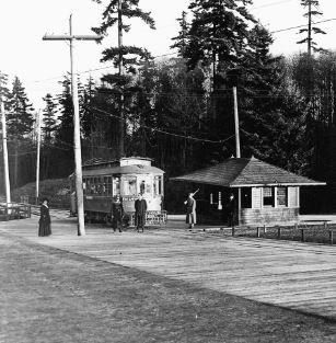
1900: George F. Cotterill, assistant City Engineer, designed a 25-mile system of bike paths. He included a bike path that is essentially the route of Magnolia Boulevard today, connecting to Interbay via Thorndyke Avenue. (Mr. Cotterill went on to serve as state senator and mayor and finally as Chief Engineer of the Washington State Department of Highways.)
1903: Olmsted Brothers Comprehensive System of Parks and Parkways for Seattle describes route of the proposed “Magnolia Bluffs Parkway” (No record of influence on the final route selection; no drawings or designs found. A photograph of the bluff attributed to the Olmsted Brothers shows an exposed cliff face with dense coniferous forest on top. The photograph is too grainy to determine the numbers of madrona that may have been present.
1904: Park Board Annual Report describes boulevard and Magnolia Park, but the Board did not take implement the proposed action.
1908: Olmsted Brothers Comprehensive System of Parks and Parkways for Seattle again describes route of the proposed “Magnolia Bluffs Parkway” (No record of influence on the final route selection; no drawings or designs found.) 1909: Park Board Annual Report again describes boulevard and Magnolia Park. 1909: Real estate developers increase efforts to sell lots on Magnolia, but steep slopes and distance from development limits interest by potential buyers.
1910: The route for Magnolia Boulevard is laid out by Samuel C. Lancaster, consulting engineer. (During this period he was also working on the Columbia River Gorge Highway.) The City began acquiring the property through donation and condemnation.
1912: The City issues a work agreement for construction of Magnolia Boulevard. Grading and macadamizing begins.
1916: Magnolia Boulevard is completed to Fort Lawton.
1924: By now, ten homes are located on the boulevard (including a large English Tudor owned by H.W. Parrish).
1927: Perkins Lane is built.
1928: A plan to pave boulevard is not carried out, but subsequently WPA labor was used to grade portions of the boulevard and perform other labor.
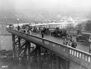
1928: Garfield Bridge is constructed from Galer to the then existing trestle across the mouth of Smith Cove at the current location of the Magnolia Bridge.
1929: The Park Board develops West Raye Street down to Perkins Lane.
1930: The Carleton Park Improvement Club protests cutting and destruction of madrona trees along the boulevard. According to the Club’s resolution, the Park Board had authorized cutting of some trees at the request of “certain” property owners. A letter from the Park Board to the Improvement Club in the following year notes that the Park Board did cut some trees, but states that most of the cut trees were removed by vandals.
1931: In February, the Park Board writes to the Carleton Improvement Club requesting help in tracking down vandals who ringed the bark of forty-one madronas tree in the vicinity of West Howe Street. In December, the Park Board writes to Carleton Park Improvement Club outlining proposed maintenance. (There is no record of whether proposed actions were carried out.) Proposed maintenance: cutting of willow and alder; removal of some madrona standing directly on edge of bluff (“The trees contribute to the sloughing off of the edge of the bank, for the reason that the wind sways them and loosens the soil.”); thinning of madrona groves in an effort to promote full crowns; cutting back flowering shrubs (spiraea and syringa) to encourage new growth; removal of “dangerous limbs and dead tops”; removal of “alders and similar soft woods that are short-lived”.
1935: The Park Board requests that the police to arrest or fine a property owner who illegally cut a tree on the boulevard.
1940s: Major slide occurs on south side of boulevard between Galer and Eaton.
1945: The wooden Howe Street bridge is replaced by a concrete structure.
1950: “The Battle of the Boulevard.” City planners decide that boulevard should be an arterial parkway: widened, paved and with sidewalks and drainage. Residents at the time fought the action for three years, being particularly concerned that the sidewalk on the north side would take out rockeries. During this time arguments continue about which madronas to leave or take out.
1953: The City and residents reach an agreement and formed and Local Improvement District (L.I.D.) to fund proposed improvements. The existing road is constructed: forty feet wide, with curbs, gutters and a sidewalk on the water side. Total cost: $379,408 paid for with proportioned assessments from the City Street Fund, Park Fund and abutting property owners.
1969: Magnolia Chamber of Commerce dedicates Memorial Viewpoint on the 2200 block in recognition of W. Robert England. 1970s: People begin to notice the decline of madronas in the Puget Sound region.
1980s: The City gradually reduces the frequency of clearing vegetation to maintain views.
1991: In response to complaints about lack of view clearing, Terry Brady, DPR Director of Grounds Maintenance, meets with various groups of interested citizens and agrees upon a three-year minimal maintenance plan. DPR conducts view pruning and deadwooding along Magnolia Boulevard. 1994: (April) Members of the Friends of Discovery Park presentPacific Madrone Preservation in Seattle a madrona training session that initiates a madrona database project.
1994: (June) Five madrona trees removed from boulevard by DPR because they were defoliated and two contained heartwood rot. Public outcry ensues.
1994: (June) In response to concerns resulting from removal of the trees, DPR staff meets with a group known as Save Magnolia’s Madronas. In subsequent months, DPR also receives complaints from the public about the lack of view clearing.
1994: (September) The Draft Interim Landscape Plan is issued for review.
1995: (April) A symposium entitled “The Decline of Pacific Madrone” is held at the Center for Urban Horticulture at the University of Washington.
1996: In response to divergent public opinion, DPR begins the process of developing a vegetation management plan for the boulevard.
1996: American Forests Famous and Historic Trees, working with the Save Magnolia’s Madrones Committee, designates a large madrona on the boulevard as a historic tree (see graphic management plan for location of tree.)
1996/ 1997: Winter storms bring an unusually high level of slide activity throughout the Puget Sound region. Magnolia Bluff is severely affected.