Now: Two new things…
have happened in regard to the replacement of the current Magnolia Bridge.
First, Seattle Department of Transportation (SDOT) contracted SCJ Alliance, a local engineering firm, to do a study on options that are more economically viable than the 2005 preferred option.
According to SDOT’s Wes Duesy, Project Manager, “We are currently evaluating several alternatives (many collected from the 2002 replacement study) and some of these alternatives may or may not include construction of a new bridge. If a new bridge is considered, the alignment would be different from the preferred alternative identified in the earlier planning study. Currently we are working to develop a more cost-effective alternative that could realistically be funded for design and construction in the future.
“We realize how frustrating it can be when an alternative is identified that can’t be built. At this time, we are working to ensure the concepts presented to the public don’t have any other hidden infeasibilities. And, with our rapidly changing city and the new opportunities presented by Sound Transit’s work in the area, this takes some thorough upfront investigation. All that said, we [briefed] the Magnolia Community Council at their standing meeting on March 20 and will be engaging the broader public both through an online survey and open house event by this summer.”
Secondly, as of November 2017, a long-awaited emergency plan for getting traffic and goods in and out of Magnolia in the case of a failed bridge was completed by Seattle Department of Transportation.
It was long a desire of the Magnolia Community to have SDOT define and have in place an emergency plan that would handle traffic and goods to and from Magnolia in case of a bridge failure, Magnolia, which has 3 entrances to it all bridges, is particularly vulnerable to the problem of bridge failure. Some residents were especially anxious for a surface street emergency route and this was identified in this plan.
More from SDOT…”We’ve been collaborating with local stakeholders to develop an Emergency Transportation Response Plan for the Magnolia Community in the event one or more of the bridges are closed. The plan provides actions and processes to ensure resiliency in the transportation network including emergency contacts, transportation hubs and surface street routes into the community. Additionally, we have identified short-term solutions to improve the capacity and operation of existing routes into Magnolia.”
The complete plan can be viewed and printed here as a PDF![]() .
.
Then…
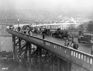
The West Garfield Street Bridge opened to vehicles and pedestrians in
December 1930. This photo was taken from the west end of the Bridge.
Photo courtesy of Seattle Engineering Department #458
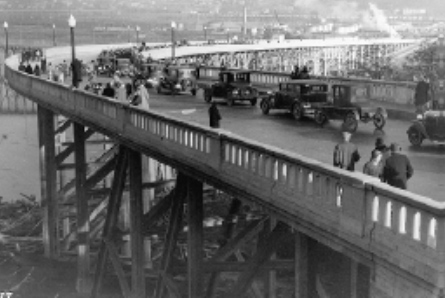
The Magnolia Bridge built in 1930 has long served the Magnolia Community. Over the years several safety issues have arisen that make the replacement of this bridge an inevitability.
On July 10, 2001, U.S. Sen. Patty Murray announced that there was disaster-relief funding for the Magnolia Bridge through the Senate Supplemental Appropriations: “These funds will set us on a course to address the serious infrastructure problems resulting from the Nisqually earthquake…. Thousands of city residents are inconvenienced daily as a result of the damaged [Alaskan Way] Viaduct and Magnolia Bridge. This assistance is a first step toward repairing both of these vital transportation links.”
According to this press release, “The earthquake…damaged 27 support braces of the Magnolia Bridge, which is the primary arterial connection from the Magnolia neighborhood to the rest of Seattle. The $9 million secured by Murray will begin the process of replacing the 72-year-old bridge and will support efforts to help the City of Seattle begin engineering and environmental impact studies to avoid a catastrophic collapse during a future quake.”
The bridge was also damaged in the 1997 mudslides (and was repaired), has some load bearing restrictions for the ramps leading down to the port property below and, according to John Buswell, Seattle Department of Transportation (SDOT) manager of Bridges and Roadway structures, the Magnolia Bridge has never been seismically retrofitted.
The Move Seattle transportation levy had monies included in it “to seriously study the funding solution for the Magnolia Bridge,” Buswell added.
In 2002, SDOT, then called Seattle Transportation, used the disaster funds and began a process to select a replacement design for the then-70-year-old Magnolia Bridge. The Capitol Hill Times reported on Feb. 20, 2002, in an interview with Kirk Jones, the SDOT representative leading the effort in the Magnolia Bridge Replacement Project, “The consultant will prepare a ‘type, size and location’ (TS&L) engineering study, which will cost between $7 million and $9 million…. The study will come from a $9 million federal appropriation secured by U.S. Sen. Patty Murray.”
A Design Advisory Group (DAG) was formed. HNTB Corp. was hired as the bridge design consultant. EnvrioIssues was hired to facilitate the public reach of selecting the preferred design. SDOT managed the overall design process.
DAG is described by SDOT documents as “a mix of community stakeholders representing many sectors and local neighborhoods…. DAG advises and provides input to SDOT and project design team during the process to identify [bridge] alternatives and design elements. DAG has considerable influence on final decisions but not ultimate authority, which resides with the mayor and the City Council.”
A 2003 SDOT Frequently Asked Questions (FAQs) document explained, “After brainstorming 25 replacement structures, two rounds of technical review and an extensive public involvement process, Alternatives A, D and H were selected for further study. Alternative A replaces the bridge with a similar facility just south of the existing bridge. Alternative D maintains the same endpoints as currently exist for the Magnolia Bridge but arcs the alignment to the north. Alternative H provides two access points: one similar to that provided for Alternative D, the other a northern route. A No Action/Rehabilitation alternative was also considered and rejected because the cost to bring the bridge to current safety and design standards was prohibitive.
It took from October 2002 until 2005 to select Alternative A and from 2005 to 2008 to do a 30-percent design (40 percent for the bridge footings) of Alternative A. And potential funding sources – a complicated process of getting federal, state and local funds – were not identified.
In March 2016, SDOT commented that it will take approximately three years for the rest of the design and permitting to be completed and construction to begin; the build will take 30 to 36 months to complete. The cost estimates for replacement rise — $196 million, if the replacement bridge using Alternative A was built in 2009. In the 2016 market, it would be $236 million, with a 4-percent inflation rate for every year it is delayed, according to SDOT’s Kit Loo, a member of the Magnolia Bridge Replacement Project team at the time.
Moving forward and after all this: Alternative A is no longer in the running due to cost and other traffic considerations that have arisen since its selection. SCJ Alliance and SDOT with the community will be looking for realistic up-dated options that could be funded and built to replace the current Magnolia Bridge.